Sunset in the Coconino National Forest, looking northeast toward Sedona, AZ, 4/17/15

Monday, August 30, 2010

Blue Ridge Parkway (NC), Part 1, August 26-30

More than 200 overlooks on the
Blue Ridge Parkway
From the planning stages of this cross-country trip, I was looking forward to driving the Blue Ridge Parkway.  Although not a National Park per se, it is managed by the National Park Service. 

The vistas show layer after layer
of mountains in the distance


This 469-mile manicured road runs through the rugged mountains of North Carolina, then north into Virginia.  It has a total of 26 tunnels, over 200 overlooks, 4 lodges, 6 restaurants, 8 campgrounds, many hiking trails, and too many associated natural and cultural sites to count. 


Morning fog in the valleys

This is one of the most biologically diverse areas in the world.  And the Blue Ridge Mountains themselves are among the oldest in the world.  It is truly a magical place.

I spent more than 3 weeks on the parkway because there was so much to see, do and experience.  So, to make the blog post more manageable, I'm breaking it into 3 parts.

The highest elevation on the Parkway
is in North Carolina.


I drove the parkway from The Great Smoky Mountains National Park toward Shenandoah National Park, from south to north.

In this southern-most section, I found my favorite campground on the Parkway, Mt. Pisgah ... quiet, lots of nice sites, clean bathroom and showers. 

Rock outcroppings line the parkway,
ancient sentries of the journey.


I also thoroughly enjoyed the Folk Art Center that is managed by the Parkway.  Unfortunately, I couldn't take any pictures there ... but, the handwork, carvings, musical instruments, and more were wonderful to see.  My favorite piece was a small wooden carving of an older mountain woman with a nail in her mouth, wielding a hammer, working to shape a horseshoe on an anvil.  I loved the implied "can do it" meaning.


Craggy Gardens area is covered with
blooming rhododendrons in the spring.


.
Driving through one of the 26 tunnels.
Mt. Mitchell, the highest peak
east of the Mississippi.
originally posted 10/4/10

Saturday, August 28, 2010

The Great Smoky Mountains, August 26-28


Elkmont Campsite,
this year and last
I love The Great Smoky Mountains National Park!  John and I were there in June 2009 to see the synchronous fireflies.  I was glad to return again to explore some of the other nooks and crannies that I didn't get to see last year.  I started at the far east end of the park at Big Creek, took scenic Foot Hills Parkway, then followed Hwy 32 and Hwy 73 along the northeast edge of the park into Gatlinburg.  What gorgeous roads ... my favorite kind of driving. 

Falls on Laurel Creek
Once in Gatlinburg, I headed for the Roaring Fork Motor Nature Trail, one of my favorite experiences of our '09 trip.  Unfortunately, it was closed for repair.  So, for "old times sake" I went on to Elkmont and stayed at the same campsite that John & I occupied last year.  It was as beautiful in August as it was in June ... but this time without the fireflies.
Wild Turkey at Cades Cove
The next day I drove out to Cades Cove, stopping at a roadside trail labeled "Quiet Walk." It was a beautiful walk, but it wasn't quiet at all being just off the main road. I also checked out the falls on Laurel Creek. The Cades Cove Loop road is one-way. It's known as a great place to see wildlife. And, sure enough, I saw some bucks, wild turkeys, and several black bears -- a mature adult and a young adult. I decided to take the Rich Mountain Road north, out of the park. It's a park-maintained dirt road, with lots of twists and turns, and I was told another good place to spot bears. To reach that road, I again needed to go about 1/3 around the Cades Cove Loop.
Bear Cub running to my car


About half way to my turn off I saw a bear cub.  No mama bear was in sight.  I had all my windows rolled down and was enjoying a mid-morning snack of crackers and juice.  Well, I think that little cub thought he'd like some too!  At one point I thought he was going to try to climb into the car with me!  He got so close to me on a bank that I could have easily reached out and touched him.  I rolled my windows up, but he kept following for about 200 yards ... and I think he would have kept tagging along except a couple got out of their car to take pictures and scared him away.   My travel down Rich Mountain Road was beautiful, but I didn't see any more wildlife. 

Bear Cub followed me 200 yrds


The proof from US129photos.com
to show that I conqured The Dragon!


 On the advice of a ranger, I made my way further west, outside of the park, to another scenic drive -- The Cherohala Skyway -- which was spectacular. To get there, I took two more great drives. One was the scenic Foothills Parkway on the west side of the park and Hwy 129, the Tail of the Dragon. I didn't know that Hwy 129 was a famous road. I've since read that the portion I drove between Tabs Cat Bridge and Deals Gap is 11 miles long and contains 318 curves. It's said to be especially enjoyed by sports car drivers and motorcyclists. I drive a Prius, and I found it fun too! I guess to prove that you've actually been on The Dragon, photographers are placed at a few of the curves with big banners advertising the web site where you can purchase your picture. An unexpected treat.


Rain Storm from Cherohala Skyway
After driving back from the Cherohala Skyway, I overnighted just north of the park. The next morning I stopped at the Little Greenbrier School on my way to the main Newfound Gap Road. This drive takes me down the middle of the park from Tennessee to North Carolina. I was on my way to take one more scenic drive, the one-way Balsam Mountain Loop. This park-maintained dirt road provided a reverent, church-like drive. I saw no wildlife, but these deep woods felt so surreal ... misty, wisps of clouds, and a few shafts of sunlight every now and again. How fortunate I am.

Little Briar School House


Inside Little Briar School House


Hiking

Hiking

A view from Balsam Mountain Loop

Rain runoff on Balsam Mountain Loop
originally posted 9/28/10

Thursday, August 26, 2010

Cumberland Gap, August 25-26

Metal Sculpture Depicting
Boone with Indian Guide
When I heard about the Cumberland Gap National Historic Park, my mind and imagination went immediately to Daniel Boone's TV exploits.  As a child of the 50's and 60's, Daniel Boone has been immortalized in the likeness of Fess Parker, who also played Davy Crockett.  

Large Painting in Visitor Center
showing Boone leading pioneers
through the Cumberland Gap
on the Wilderness Road
But, once I got there I learned of a man, not so much in a coonskin hat, but a man who was commissioned to blaze a Wilderness Road through the Cumberland Gap.  This gap is the only natural opening for hundreds of miles in the Appalachian Mountain System.  Boone and his wife faced much hardship as he attempted to build the road multiple times, including the death of two of their sons.  Eventually he did finish the road and led pioneers through to settle into Kentucky.

Canon at an earthworks fort where
Civil War soldiers dug in.
After overnighting at the park's Wilderness Road Campground, I took a couple of scenic drives and hikes.  I learned that during the Civil War, both the Confederates and Union occupied the Cumberland Gap at different times.  They were not driven off by the opposing side, rather the bad winter weather made them abandon their posts.  Finally neither side used the Cumberland Gap as a strategic position because the road became impassable.

From atop the Pinnacle Overlook I could see three states -- Virginia, Tennessee and Kentucky.


On the ridge through the trees --
Virgina in front,
Tennessee to the left,
Kentucky to the right.


Can you see my friend who
visited me at the overlook?


originally posted 9/28/10

Wednesday, August 25, 2010

West Virginia Rivers, August 24-25

Summerville Lake on the
Gauley River
Now in West Virginia, I visited the New River Gorge National River, with Gauley River National Recreation Area to the north and Bluestone National Scenic River to the south.  Truly "almost heaven" ... I loved this place.  The New River, despite its name, is an extremely old river.  One of the oldest in the world.  And it felt old as I let myself be surrounded by its water, woods and wildlife.

The New River


I spent the days driving back roads, learning of both its natural and human history.  It's an area rich in coal, and until the coal just got too deep to mine, this land was stripped of its resources ... lumber, game, soil.  Now, it's recovering amazingly well.


Grist Mill at Babcock State Park


The campgrounds at New River Gorge are primitive and free ... which I love! 

On one of my drives, I stopped at Babcock State Park, adjacent to The New River Gorge NP, to visit their grist mill.

New River Gorge Bridge
longest arch in the US, 1700'
(too wide for my camera to capture)
highest vehicle bridge in Americas, 867'

dense woods, old rock


originally posted 9/20/10

road to campground

stone steps up to overlook

Sandstone Falls, New River


Where coal is found in
the rock layers,
Visitor Center Display


Monday, August 23, 2010

A Pennsylvania Friend and Friendship,
August 21-23

Pat's home in the Allegheny NF
Pat has a wonderful home in the Allegheny National Forest in northwest Pennsylvania.  She is a fellow traveler who invited me to her home while I was on my national park tour.  I jumped at the chance. 
Pat and her Aussies

While there, we sat and talked for hours about everything -- traveling and staying home, things natural and things spiritual, living and dying, love of the out-of-doors and enjoyment of things domestic, our beloved pets and a love for the wild ones, and on and on.   Her two Australian Sheppards were fun to be around and made me miss our two dogs.

Pat's My Wee RV
I got a tour of her mini van and how she has it set up for travel.  I love the license plate that says "My Wee RV."  She's done some creative installations with her cot and curtains.

Driving onto the grounds of Friendship Hill


After such a good visit with a friend, I went to the Friendship Hill National Historic Site in southwest Pennsylvania.

Gallatin as surveyor
Friendship Hill was the home of Albert Gallatin.  He named the place "Friendship Hill" for his friendships with local businessmen.  Born in Switzerland in 1761, he immigrated to the US in 1780.  Gallatin came to western Pennsylvania as a surveyor.  He was a land speculator and owned several types of manufacturing firms.  He served in both the House and Senate, 13 years as Secretary of Treasury, and as Minister to both France and England.  Gallatin's contributions, however, have been overshadowed by his contemporaries, Thomas Jefferson and James Madison.

Friendship Hill Home

While I was at Friendship Hill it was raining.  Inside the home, I took a self-guided tour.  The home had been added onto many times over the years.  The grounds and the home were both beautiful, even in the rain. 


A bedroom at Friendship Hill
Doe and Fawn at
Friendship Hill
originally posted 9/19/10

Saturday, August 21, 2010

More Sights in Upstate NY, August 19-21

Giant Chair in front of the
Adirondack Museum
My next stops were all in Upstate New York. After a quick visit to the Adirondack Museum, I explored Fort Stanwix and the Women's Rights Museum, two National Park Service sites; then I checked out Niagara Falls.


Fort Stanwix National Monument is in Rome, NY. The saying that “all roads lead to Rome” aptly applies here. This fort was strategically situated on both north-south and east-west routes. In addition, it was on a major portage between the Mohawk River and Wood Creek for travel from the Atlantic Ocean to Lake Ontario. 

Well fortified entrance into
Fort Stanwix
This year, Fort Stanwix is celebrating 75 years with the National Park Service. The following weekend, they were to have lots of activities, reenactments, and general hoopla. When I was there, it was actually pretty quiet.
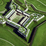
Star shape fort design


Although it is now surrounded by a modern city, it's easy to see why the fort was placed where it is. It's on high ground and protected on one side by a natural creek. This fort is not shaped like other forts I'd seen. That is, it's not square or rectangle. It's kind of a star shape. By utilizing this shape, which is French in origin, the soldiers defending the fort from atop its walls had no blind spots. I was impressed (pic from http://www.nps.gov/fost/images/FOST_green_trim.jpg).  Fort Stanwix is one of a handful of US forts that never surrendered.
Cooper who makes wooden barrels

I got a chance to speak with a "cooper" who, dressed in period clothing and using period tools, makes wooden barrels for storing food and supplies. I made the mistake of saying that it kind of reminded of basket making. Oh my, was he ever insulted; open mouth, insert foot. All in all tho', it was very interesting and definitely requires a lot of knowledge and skill.

After spending the night at a nice private campsite in Cayuga Lake State Park, I visited the Women's Rights National Historical Park which is in Seneca Falls, NY, the birthplace of the movement. In 1848 Elizabeth Cady Stanton and four other women called the First Women's Rights Convention and wrote the Declaration of Sentiments which was modeled after the Declaration of Independence.

Life size sculpture of key participants
in the first Women's Rights Convention
It reads, in part: 

"... We hold these truths to be self-evident; that all men and women are created equal; that they are endowed by their Creator with certain inalienable rights; that among these are life, liberty, and the pursuit of happiness; that to secure these rights governments are instituted, deriving their just powers from the consent of the governed. Whenever any form of Government becomes destructive of these ends, it is the right of those who suffer from it to refuse allegiance to it, and to insist upon the institution of a new government, laying its foundation on such principles, and organizing its powers in such form as to them shall seem most likely to effect their safety and happiness..."

Restored Cady Home
After exploring the museum, I went to the restored home of Elizabeth Cady Stanton (1815-1902) where a ranger gave some history and insight into her life in Seneca Falls. She was very involved in her community at many levels, had a successful marriage and raised a family of 5 boys and 2 girls. Strangely enough, the thing that I came away with, more than anything, was that she was a great mother. And, all of her work and leadership in the women's rights movement is very much part and parcel of what made her a good parent. It somehow makes me proud of the choices I've made as a woman and mother.
Lock on Cayuga-Seneca Canal

On the way from Fort Stanwix through Seneca Falls to Niagara Falls I followed the Erie Canalway National Heritage Corridor.  Here is a picture of a lock on the Cayuga-Seneca Canal, which raises/lowers boats 50 feet.  The employees there were very proud that they had recently upgraded to a hydraulic system.

Rapids just before Niagara Falls
Niagara Falls was one of those places I just wanted to see while I was on this journey, even though it's not a national park. It is a NY State Park and a natural wonder. It certainly lived up to my expectations in its grandeur. It's huge, humongous, and very loud. I was surprised, though, that there were such big rapids before the falls. I was expecting a calm river before it went over the crest, like Snoqualmie Falls near my home.

Niagara Falls from the US side


I had also hoped to visit the Theodore Roosevelt Inaugural National Historic Site in Buffalo the following Saturday morning.  Unfortunately, I couldn't find parking because the it was the day of the annual Delaware Avenue Tour of Homes event.  I did, however, enjoy the drive around the area myself.  It felt old and was well kept, and the architecture was amazing.

Lake Ontario
Before heading south, I took a little excursion north to see Lake Ontario.  And, then the next day, on my way to visit a friend in northwest Pennsylvania, I took the scenic route and stayed as close to Lake Erie as possible.

originally posted 9/18/10