Sunset in the Coconino National Forest, looking northeast toward Sedona, AZ, 4/17/15

Monday, June 28, 2010

Fort Smith NHS (AR), June 28

On the way to my next National Park, I visited Fort Smith National Historic Site at the Oklahoma-Arkansas border.  It was at the edge of indian territory where "hanging judge" Judge Isaac C. Parker presided in the late 1800's.  In his 21 years there, he sentenced 120 people to death for which 79 died at the gallows during that tenure.  During the anniversary of each hanging, a hangman's noose is hung from the reconstructed gallows.  I was there at the anniversary of John Thorton's death.

After learning about the court case surrounding Mr. Thorton's guilt and subsequent hanging, I turned my attention to the nearby memorial to the Trail of Tears

Our government forced Native Americans to abandon their homelands, trek many hundreds of miles while experiencing inhospitable conditions, hunger, sickness, and the death of over 10,000 in order to relocate them onto reservation land.  My re-focus from the hanging of a guilty few to the death of innocent multitudes was striking.  I was, and am saddened and ashamed of this part of our country's past.   This picture is looking across the Arkansas River from near the Trail of Tears Memorial.
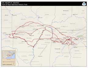
Perhaps later in this journey I'll hike some of the trail that commemorates the Cherokee's Trail of Tears through Alabama, Arkansas, Georgia, Illinois, Kentucky, Missouri, North Carolina, Oklahoma, or Tennessee (http://www.nps.gov/trte/planyourvisit/images/TRTE_ContextMap_20091104_lowres_thumbnail.jpg).

originally posted 7/24/10

Donna and In Lon Shka, June 26-28

In making plans to visit Donna, I was honored to be invited to attend the Osage ceremony of In Lon Shka in her town of Pawhuska, OK.   Donna is a talented artist and seamstress who researches, creates and teaches how to make Native American regalia for a varienty of tribes.  Although not Osage herself, she has been accepted as a member of one of the Osage families.  Here is Donna in her Seminole regalia, pictured with Jinx, my Osage host.

My time there was enlightening and humbling as I moved, with Donna's help, within their community and culture.  For example, I learned that being a guest was considered an honor to the host.  Also, gift giving is a significant part of this culture.  Gifts were offered with no expectation of getting something in return.  It seemed truly about the giving of gifts, not the familiar exchanging of gifts of western culture.

In addition to spending time at Donna's home, I got to spend time with her extended Osage family.  Jinx, the matriarch, is a strong woman who opens her home to her extended Osage family for the yearly In Lon Shka ... over twenty people this year.  Being there had the familiar chaos of my own family reunions, multiple generations catching up on news, laughing, being silly, loving.  The pride of being Osage as expressed by Jinx and her family was enlightening as they shared some of their heritage with me in both words and action.

In Lon Shka itself was wonderful.  The regalia of the 400+ dancers was beautiful.  Each song's melding of sounds -- drum, bells, and voices -- will stay with me for a long time.   The ins and outs of the ceremony, the difference of dance between the men and women, the process of acceptance of men into the circle, and the differing roles of various families and individuals are some of the things I only learned little about.

As Donna explained to me, I have left a bit of my spirit in her care, and a bit of her spirit remains in my care.  I thank her spirit and the spirits of her Osage extended family for traveling with and enlightening me.  I hope my spirit is blessing them as well.

originally posted 7/24/10

Friday, June 25, 2010

Visiting in Colorado, June 23-25

As I concluded my tour of the national parks west of the Mississippi River, I headed southeast and took advantage of Karen and family's hospitality again in the mountains of Colorado.  It so happened that another traveler, Ron, was also there on his way to the northwest ... a serendipitous crossing of paths.


Ron has one of the coolest custom vans that I've seen.  It's a Sportsmobile with a "penthouse" top that raises up, a brush guard w/wench, solar panel, a pivoting hitch for when he's hauling his large trailer ... it just looks macho!  Inside it's decked out with a bed, microwave, frig/freezer, commode, running water, extra batteries ... luxury! 

After a yummy pizza and a pleasant visit, Ron continued on his journey the next morning.  During the day Karen, daughter Katie and I went into town for a fun lunch and shopping.  I especially enjoyed just sitting on their patio, visiting, checking out the scenery, watching the wildlife and playing with the dogs.  What a nice stay!


Thanks to Karen for the hummingbird, cactus, and deer (framed by the arch at the gate) pictures.


originally posted 7/6/10

Wednesday, June 23, 2010

Rocky Mountain National Park, June 20-23

The Rocky Mountain National Park is the highest park on the mainland USA.  Taking the Trail Ridge Road was amazing, going east to west and back, and climbing over 12,000 feet.  I could really feel the altitude as I bundled up against the wind and explored the alpine tundra above the tree line.  I  saw a yellow-bellied marmot and enjoyed the little yellow wild flowers coming up from where the snow had already melted.
 
From a distance you can see how the frost pushes the rocks up to the tundra's surface creating some cool patterns (circles, hexagons).

Moose, elk, deer and bear call this park home.  I saw all but the bear ... but, heard stories of them climbing into cars for food when the windows were rolled down.

I stayed at Moraine Park Campground next to a little meadow and rock outcropping.  The only large mammals I saw there were my fellow humans.  But, I kept the windows rolled all of the way up, just in case.

In this park you could go from the almost-barren tundra down to lush green valleys, and to the forests in between.  The river in the picture is the Colorado, toward the beginning of its life southward.

Unfortunately, many of the park's trees have been killed by the native pine beetle.  Whole mountain sides are filled with dead trees. 

Although the NPS is working to save trees of historic or aesthetic value by using pesticides and pheromones, these tactics won't work on a large scale.  And the pine beetle's native territory is huge, from Canada to Mexico.  The park rangers frame this destruction in terms so that visitors can see how the forest will eventually renew itself ... similar to after a major fire.  In the meantime, the aspens and sapling lodge pole pines are finding new places to grow.

originally posted 6/30/10

Saturday, June 19, 2010

Wind Cave National Park, June 17-19

Wind Cave National Park is just south of Custer State Park.  In fact, I inadvertently took a gravel road into Wind Cave NP off of the State Park's Wildlife Loop Road one day.  Wind Cave's claim to fame are rare cave decorations called "box work."  It kind of reminds me of lace hanging down from the ceiling (pic: http://www.nps.gov/mwr/customcf/apps/CMS_HandF/Pictures/WICA_Boxwork-for-DYK.jpg).  It also has some beautiful frostwork that look like suspended sparkly white snowflakes in the light (pic: http://www.nps.gov/wica/naturescience/images/Frostwork-35.jpg).

Wind Cave is the 4th longest cave in the world.  Because of all of the rain that this area has been having lately, this normally dry cave was dripping wet when I visited it.  One amazing fact about this 134-mile-long cave is that it is below only a 1 square mile surface area above ground.  Another amazing fact is that this cave breathes.  When the barometric pressure is high (rainy days), the cave breathes in.  And when the barometric pressure is low (sunny days), the cave breathes out.  You can feel its "breath" as wind when you are in the cave.  The wind was measured to be over 75 MPH at one time.  When I was there, you could barely feel a gentle breeze as it was breathing in.

Thursday, June 17, 2010

Jewel Cave National Monument & Custer State Park, June 15-17

The Jewel Cave National Monument is just east of Custer State Park.  The cave is different than the other two I'd visited recently (Carlsbad and in Great Basin).  It had calcite spars that grew from the walls, looking just like jewels (pic: http://www.nps.gov/mwr/customcf/apps/CMS_HandF/GreenBoxPics/JECA_spar%20photo.jpg). 

It also had very rare hydromagnesite balloons that hang from the ceilings and walls.  (pic: http://www.nps.gov/jeca/images/Hydromagnesite-Balloon.jpg).  Unfortunately, the tour that I went on didn't have any of these balloons ... but they are so cool all the same!

At 135 miles, Jewel Cave is the second longest cave in the world.  The first longest is Mammoth in Kentucky that I plan to visit in a few months.

I camped two nights at Center Lake at Custer State Park.  As in the "White Hills," it rained alot in the "Black Hills" too.  I got a great thunder and lightening show one night.  I could hear the thunder after it passed for miles away as it echoed in the valley I was in. 

Kudos to the State of South Dakota for making Custer State Park a great place to vacation.  One of my favorite things to do here was to take their wonderful scenic drives.  The Iron Mountain Road has 3 tunnels that perfectly frame Mount Rushmore National Memorial as you drive through them.  It also as a couple of pig-tail turns where you go under a bridge that you just crossed over (pic: http://gfp.sd.gov/state-parks/directory/custer/images/pigtail-bridge.jpg).  Amazing and fun!
  
The Needles Highway is also in this park and is probably my all-time favorite drive so far.  It has spires of granite that line the road as they reach for the sky ... feels almost like church.  One place is even called "The Cathedral."  Sylvan Lake is off of this highway where granite spires come right out of the water ... another amazing place. There's also several very cool one-lane tunnels blasted through the granite to make this road.   Close to one of those tunnels is a rock formation that looks just like a hole in a needle that you would thread.  Pretty amazing. (pic: http://www.custerresorts.com/images/apg_1206024000.jpg)

The Wildlife Loop Road is the drive I took most often to see buffalo, elk, pronghorn, burros, prairie dogs, blue birds, deer, mountain goats, big horn sheep ... you just never knew what was going to be there.  I also took the back roads that are inside of the loop for some more great scenery and wildlife.  The park does a good job at keeping all of their gravel roads well groomed.  Pronghorn were everywhere (pic: http://gfp.sd.gov/state-parks/directory/custer/images/wildlife/pronghorn.jpg).

originally posted 6/18/10

Tuesday, June 15, 2010

Badlands National Park, June 13-15

The Badlands National Park is a cool place (pic: http://www.nps.gov/mwr/customcf/apps/CMS_HandF/GreenBoxPics/BADL_web078(2)shaina.jpg).  Although I'd been here several times, I couldn't pass it up.  My father grew up just outside of the park; so, I have some sentimental attachments to it.  It was exceptionally green with lots of wildflowers this year given the record amount of rain over the past several weeks.  And, it rained buckets while I was there too.  Fortunately, there were also times when it stopped raining as well.

In addition to green prairie, the rain brought out the color striations in the hills ... reds, yellows, greens, grays, browns.  The vistas were amazing (pic: http://www.nps.gov/mwr/customcf/apps/CMS_HandF/GreenBoxPics/BADL_ShainaConata.jpg)

Similar to preferring the name "Bear Lodge" over "Devils Tower," I prefer the Lakota name "White Hills" over "Badlands."  I especially like the name "White Hills" when I think about their proximity to the "Black Hills" of South Dakota where I spent the next few days of my journey.

Note:  I got the replacement for my camera phone ... but, I'm not in T-Mobile territory.  So, will need to wait until I get into Colorado before I'll have a camera again.

originally posted 6/18/10

Sunday, June 13, 2010

Devils Tower, June 12-13

After overnighting in Cody to wash clothes and car, I got to Devils Tower National Monument in northeast Wyoming (pic: http://www.nps.gov/imr/customcf/apps/CMS_HandF/GreenBoxPics/DETO_towerweb.jpg).  I had a nice camping spot where I could see the tower as the sun set and again in the mist at sunrise.

The Native American names for this place are more fitting I think -- Bear Lodge, Bear Tipi, Bear Hat.  It is a spiritual place and several tribes were using the grounds for traditional ceremonies at the time I was there.  I'm glad that the National Park Service recognizes their right to this sacred site and encourages visitors to give them privacy.

originally posted 6/18/10

Friday, June 11, 2010

Yellowstone, June 6-11

Yellowstone National Park is amazing.  Its geology, including the thermal features are extraordinary.  The wildlife are abundant.  And, the scenery and vistas are breathtaking.  It's a huge and mostly wild place.

Unfortunately, my camera phone was stolen so, I only have a few of the pictures I took of Yellowstone ... but, I've supplemented with others that I found online (with due credit).  The pictures I do have showed the amazing colors of the mudpots and hot springs toward the south end of the park (West Thumb).  The minerals in the mud and rocks, and the bacteria and algae give the features endless variations of color.

During the first part of my visit, most of the lakes still were covered with ice.  By the time I left, most of the ice had melted.

I visited Old Faithful, first watching it erupt from the porch of the Old Faithful Inn upon arrival ... and then 90 minutes later from the "ring side" bleachers.  In the interim, I warmed myself by the fire in the lodge's stately lobby (see pic, http://www.nps.gov/yell/planyourvisit/images/Ofinnint.jpg).

I also spent time at Mammoth Hot Springs in the northwest corner of the park.  In town, the wild elk grazed on the lawns of the administration buildings and resorts like horses in a pasture.  In Mammoth, limestone and hot water made other-worldly terraces with bacteria-colored waters. (see pic, http://www.nps.gov/archive/yell/features/mammothtour/images/Minervaterrace.jpg)

Norris Basin, just south of Mammoth, boasts the tallest geyser ... but, it displays its tallness very infrequently.  I got to see only 10' eruptions.   It's called Steamboat Geyser.  I wonder if it's called "steamboat" because it sounds like an engine chugging along.  It's also the place I last saw my camera phone.

I especially loved the Lamar Valley in the northeast corner of the park.  It's the greenest green mixture of rolling hills covered with mostly tall grass and some scrub brush, mixed with lodge pole pine forests ... creeks, rivers and ponds.  With all of it's peaks and valleys, it's somewhat sheltered.  If I were a wild thing, this is where I'd want to live.   Here I saw many large mammals, most with young -- bison, pronghorn, moose, big horn sheep, a grizzly bear with 4 cubs (unusual), black bear, coyote, and elk.  They say wolf are in the Lamar Valley as well, but I didn't see any there (but saw a lone black wolf in the Canyon area).  I tried to find a picture that showed the late spring green of the hills, but couldn't ... so, just imagine ...

My most exciting animal encounter was at the Norris Campground.  I choose a site that backed up to a ravine, thinking that I might see animals down there later in the day.  When I pulled into my spot that evening, I noticed a herd of buffalo skirting the campground.  As I watched, I got to see the cows and calves grazing their way down that ravine to their night-time spot in the woods further behind.  The "big daddy" put himself between the campers and the rest of the herd, sending campers scurrying out of his way.  He was big ... probably 6' at the withers.  When he got close to my site, I got in my car and watched him as he came nearer and nearer.   At his closest, we were looking eye to eye about 5' from my window as he was grazing on the uphill side of my car.  When he moved on, I got out to watch him from a distance.  Then a couple of younger males came a little too close for comfort so I readied myself to get in my car again and said to them "it's OK, I'm not going to come any closer."  When I said that, they turned away ... but, the big daddy sauntered closer as if saying "I want you to get in your car now, and stay there" ... I obliged.  He bedded down for the night 15' from my car door.  I'm sure glad I wasn't tent camping!  This picture is how it felt: http://www.animalsintheworld.com/animal_pictures/buffalo_car.jpg.

And, I can't write about Yellowstone without remembering going there with Elise and her family two years ago.  It was one of her last wishes.  Here is a picture she took of a beautifully-colored hot springs.


originally posted 6/17/10

Sunday, June 6, 2010

Grand Teton National Park in WY, June 1-6


I thoroughly enjoyed the Grand Teton National Park ... trees, lakes,
wildlife, and the mountains! Here it was all about the mountains --
the mountains and clouds (pic1), the mountains and sage (pic2), the
mountains and a lone aspen (pic3), the mountains with storm clouds
(pic4), the mountains through the Jackson Lodge window (pic5), the
mountains while fishing on Jackson Lake (pic6), and the mountains as I
was leaving the park (pic7).

The first night I camped at Jenny Lake Campground, which is in the
park. It was an OK spot, but expensive at $20/night. So, I asked the
ranger and he pointed me to a great little free campground just north
of the park off of the John D. Rockefeller Jr. Memorial Parkway. It
was the best camping ever -- quiet with the sound of the river -- and
I met other women going solo there too!

The Grand Tetons had some great scenic drives in the park and into the
neighboring national forests. I saw my first wild moose, buffalo with
their calfs, elk, pronghorns, ravens, blue birds, yellow-headed
blackbirds ... My camera doesn't take good far away pictures, so the
pics didn't come out ... but, seeing them was cool all the same.

originally posted 6/7/10

Tuesday, June 1, 2010

Great Basin National Park, May 31 - June 1

I expected Great Basin National Park in Nevada to be all about the desert, given that the state itself is actually one big basin.  In this park, however, I focused more on a mountain and a cave.  Wheeler Mountain at over 13,000 feet provided a wonderful scenic drive.  There was still about 3 to 4 feet of snow at the top of the drive.  If I wanted to make the hike, I could have seen some 5,000 year old trees, the Bristle Cone Pine Forest.  The campground at about 10,000 feet had been plowed and I considered overnighting there but the altitude was a bit much.  So, I stayed at the Lower Lehman Campground, named for the man who discovered the cave.
Similar to the Carlsbad Caverns, many of Lehman's decorations were back lit and provided enough light for my flash-less camera.  Some of the formations were still growing, wet from the melting snow above.  Very cool stuff -- straws, stalagmites, stalactites, popcorn, columns, and draperies. 

But, this cave had other rare decorations -- bulbs and shields.  The bulbs grew off of the ceiling in one of the larger rooms and looked like turnips or radishes, but hollow inside.  I couldn't get a good pictures of those.  But, I did get a picture of one of the more famous shield formations called the "parachute" ... it looked more like a jellyfish to me!  Scientists still have yet to figure out how bulbs and shields are formed.

I enjoyed a drive out to the Gray Cliffs where I spied several more caves with signs indicating that you needed a permit to enter.  I was told that petroglyph are in those caves but they were off limits right now because bats had returned to roost in them.  Cool to know, but too bad I couldn't check them out.

The part of the park that I spent my time in was not at all desert-like.  I loved my little campsite next to a small trickling stream lined with river birch where I watched a busy little ground squirrel go in and out of his den ... blissfully ignorant of my presence.
On my way to my next destination I passed by the Little Sahara National Recreational Area in Utah.  On my GPS map, however, it said it was a National Monument ... so, I stopped.  It's a huge area of sand dunes and an off-road-vehicle riders paradise.


originally posted 6/4/10