Sunset in the Coconino National Forest, looking northeast toward Sedona, AZ, 4/17/15

Sunday, September 26, 2010

A Neighbor in Virginia, September 15-19, 25-26

Char fixing
Julia's hair
After I began my National Park Tour, one of our long-time neighbors moved to Virginia to be with her daughter's family.  I was fortunate to be able to visit with Char while I was in the area.  It felt a little like being home.

Gabby with Julia
modeling bday gifts
Char is a multi-talented hard-working woman.  She's a good grandma, helping her daughter and husband with the kids.  She's writing a novel that's based on the TV show "Supernatural."  Check out this work in progress here: http://www.fanfiction.net/u/2538008/.  She's very handy and can fix just about anything mechanical or electronic.  For downtime, she enjoys playing Farmville.  And, she's one of the most giving people I know.

While at their place, I took time to rest, catch up on some online tasks, visit the Fredericksburg National Battlefield, and prepare for my trip home to John.

Castiel

Char's dog Pebbles

Playing with the kids

A dog and his couch

Chillin' with Farmville
originally posted 10/14/10

Saturday, September 25, 2010

Congaree National Park (SC), September 23-25

Board Walk Loop Hike
Congaree is the last US location to be named a "National Park."  It use to be Congaree Swamp National Monument.  But, in 2003, the US Congress made it Congaree National Park.  They removed the word "swamp" because it is not a swamp, rather it's a river floodplain.

Bald Cypress and their "knees"


I made this place my last park visit east of the Mississippi because I knew it to be hot and muggy here.  But, fate had other ideas.  It was still quite hot and humid in late September.  So, I just had to deal with it, making sure to slather on both the sun screen and bug spray.  I was sure glad to have the window screens on my "Prius RV" to keep the skeeters out and let the breeze in.

A very large loblolly pine
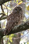
I was fortunate to time my visit with both a ranger-led canoe paddle, and an evening "Owl Prowl" hike.  Earlier in the day, I also did a self-guided hike on the 2.4 mile boardwalk through dense floodplain forest, among amazing bald cypress, water tupelo, and loblolly pine.  This is the largest remaining old growth river floodplain forest on the continent, with the largest loblolly pine tree (southern yellow pine) in the US.

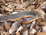
The canoe paddle on Cedar Creek was wonderful.  The creek was low and had almost no current; a very easy paddle.  We saw several birds, heard barred owls, saw several water snakes, raccoons, and a cardinal flower.  With the long Spanish moss hanging down and the bald cypress knees pointing up, it looked like cave stalagmites and stalactites on the creek.  Unfortunately, I didn't bring my camera ... I don't trust myself in a canoe with any electronic devices that aren't water resistant *lol*. 

Dwarf Palmettos
The "Owl Prowl" hike was on the same boardwalk as my morning hike, but in the pitch dark.  We heard several barred owls talking back and forth.

Every 4 to 5 years, the portion of the boardwalk that is 8' off the ground gets covered with water.  The rangers shared that the only places in the park that aren't under water are the road, visitor center, and campground.  During my visit, there was very little water.

 Despite the heat and humidity, I really enjoyed my visit to this park.
Portion of an old still
back in the woods

originally posted 10/27/10

A Change of Plans, September 25

John.  And, yes, he does play Santa!
I just found out that John has cancer.  It's a slow growing tumor so the surgery to remove one of his kidneys is not scheduled for another 3 to 4 weeks.  So, I've canceled our hotel and airline reservations to meet in New England, and canceled future rendezvous with friends on the east coast ... hopefully all to be rescheduled for a later date.  Thank you all for being so understanding and gracious.

I've started heading west, going home.  I'm taking the scenic route, but remaining close to the Interstates in case I need to be back quicker than expected.  I'll continue to catch up on my blog of traveling adventures ... thanks for your patience.

I've also just started a blog for John and I.  So, if you want to know the latest details of our lives and, specifically on John's health right now, go to http://suannejohn.blogspot.com/.

... still following my heart ...


originally posted 9/27/10

Thursday, September 23, 2010

Outer Banks National Park Service Sites (NC), September 21-23

Chesapeake Bay from north end
of Bridge-Tunnel
 To get to Cape Hatteras from Assateague Island, I continued traveling south over and through the Chesapeake Bay Bridge and Tunnel which is an amazing 20-mile long toll crossing.   Two of its tunnels dive under the water!
Oregon Inlet campsite at sunset

The Cape Hatteras National Seashore is a set of barrier islands on the Outer Banks of North Carolina.  My first night I stayed at the Oregon Inlet Campground on Bodie Island.  Here I watched the moon rise and slept to the surf's song. 
Bodie Island Lighthouse
under restoration


The next morning I tried to take the free ferry between Hatteras and Ocracoke Islands, but there was a 3+ hour wait, so I retraced my way south and visited a couple of other nearby Outer Banks National Park Service locations -- Fort Raleigh National Historic Site and the Wright Brothers National Monument.
Cape Hatteras Lighthouse

Fort Raleigh was "England's first home in the New World," 1584-1590.  Although Sir Walter Raleigh never visited this fort, he sponsored the colonization.  The fort is an earthen works; that is, the English soldiers "dug in" on this spot to defend the colony.

Earthworks of Fort Raleigh
The spot where the Wright Brothers achieved flight has been preserved.  Here I attended a ranger program sharing the events and challenges that led up to that first flight.  It is a story of science, competition, and passion.


Field where the Wright Brothers
achieved flight for the first time
 My second night was on Hatteras Island at Frisco Campground.  I had a great campsite.  It was the Autumnal Equinox and the Full Harvest Moon.  The picnic table on my site was perched on a rise from which I could see and hear the ocean.  It was private, quiet, with a spectacular view.  It was perfect ... I watched the sun set, the moon rise, a deer and doe making their way through the bush, and got umpteen mosquito bites ... well, I guess it wasn't totally perfect.

Painting based upon a photo
of the first flight

I got up early the next morning as I decided to take both the free ferry ride within the park, and the longer toll ride south to the mainland.  Thankfully, I got there early enough and was one of the last to board, sailing south toward my next stop, Congaree National Park in South Carolina.

Full Harvest Moon over the
Atlantic Ocean on the
Autumnal Equinox

Getting ready to board
a ferry from Okracoke to
Cedar Island, 2.5 hrs.

originally posted 10/26/10

Tuesday, September 21, 2010

Assateague Island (MD/VA), September 20-21

Hurricane Igor made for
rough surf and rip tides
Assateague Island National Seashore is a barrier island off the Delmarva Peninsula.  It spans 2 states, Maryland and Virginia.  I came in from the north as that is where the campgrounds are located. 
One of the wild horses

Assateague Island is probably most famous for its wild horses.

The wild horses on the northern Maryland end of the island are managed like wild animals.  That is, the NPS allows nature to take care of itself.  The only interventions they provide is putting a dying horse out of its suffering, and an innovative birth control program to keep these non-native horses from destroying the island's environment.
View of Chincoteague Bay
from Bayside Camp Ground

Recent genetic testing has debunked the folklore that the first horses swam to the island from a shipwrecked Spanish ship.  The real story is that colonists put the first horses on this island to avoid being taxed on them.  To be sure though, there are hundreds of ship wrecks off this island.

I decided to camp on the bayside of the island because it was both quieter and more private.  However, at dusk I had visitors to my campsite.  A small band of horses browsed their way through.  See the video below of one of the horses scratching itself on a tree.
A few of the wild horses
 at my Bayside Campsite

And, because the island is so narrow, I could still hear the surf as I slept.

The next day I traveled to the southern, Virginia end of the island.  To get there, visitors must drive around, off the island.

A different herd of horses live on the south end of the island.  They are owned by the Chincoteague Volunteer Fire Department and are managed like livestock instead of wild animals.  Once each year there's a round up where the horses swim across the bay for veterinarian care and to sell off some of the fouls to pay for the herd's care.
Cranes flying and fishing

Near Tom's Cove, at the far southern end of Assateague, I saw lots of birds in the salt marsh.
Surf was still rough on
day 2 on the southern end


My next destination is another NPS site and another barrier island, Cape Hatteras.


originally posted 10/25/10

Monday, September 20, 2010

A Scenic Route (VA/MD/DE), September 19-20

My next and last National Park east of the Mississippi was to be Congaree in South Carolina.  I saved this to last because I knew it to be very hot and humid, and I figured the later I waited, the cooler it would be.  I plotted my course from my current location in Virginia to Congaree.  I decided to take the scenic route south along the coast.  I searched the National Park Service web site for places to camp on the way.
Potomac River off of the
George Washington Memorial Pkwy
Fort Washington in the distance

My first stop was at Prince Williams Forest Park, a beautiful piedmont forest set aside for hiking and camping.  I took a scenic drive and had lunch.  But, it was still too early in the day for camping; so, I moved on.  I then continued my trek through Maryland, into Washington DC.  I'd considered exploring DC for the day, but decided to wait for another time.  But, I did take the scenic George Washington Memorial Parkway next to the Potomac River.

While doing my research, I was surprised to find a NPS site for camping just 13 miles from the White House, inside the beltway.  Greenbelt Park provided a beautiful oasis of green for camping.   When I come back to explore DC, this will make a great home base.

After a good nights sleep, I began my way onto the Delmarva Peninsula.  So named for the states on that peninsula -- Delaware, Maryland, and VA (Virginia).  Assateague Island, here I come!

originally posted 10/23/10

Saturday, September 18, 2010

Fredericksburg Battlefield (VA),
September 17-18

Original Stone Wall built by
Confederate Soldiers to provide
cover at the Sunken Road
Fredericksburg and Spotsylvania County Battlefields Memorial National Military Park encompasses 4 battlefields in Virginia -- Fredericksburg, Spotsylvania, Wilderness, and Chancellorsville. 

I hesitated to go to this National Park site.  I typically avoid studying events where so many experienced violent deaths at the hands of others.  This area is considered the "bloodiest landscape in America" where 85,000 were wounded and 15,000 killed, 1861-1865
Wall with bullet holes from
Battle at Fredericksburg

Yet, when I can distance myself from that horrid reality, there is much of interest -- each side's passion, political thinking, military strategies, and the documented perceptions of the soldiers and civilians.  To manage my time and emotions, and to do this visit justice to the enormous amount there is to learn, I choose to focus on the first battle of the 4, the Battle at Fredericksburg.

Kirkland Monument
Confederate soldier giving water
to a wounded Union soldier
Porch of the Rising Sun Tavern
with living history participants

George Washington's mother's home
  After checking out the Visitor's Center, I took a self-guided tour of the battlefield.  It included the sunken road where confederate soldiers took aim when union soldiers crossed the field toward them.  A portion of the Confederate-built wall still stands along the sunken road.   Some of the original structures had been restored, including the Innis House which stood in the middle of the battle.  One of the interior walls has not repaired and still bears bullet holes from that battle.  My tour ended at the Kirkland Monument honoring the mercy of a Confederate Soldier who went onto the open field, in the heat of battle, to bring water to wounded union soldiers.

Although the battle took place on December 13, 1864 on a large open field outside of town, the killing actually began on December 11th in the town of Fredericksburg among its businesses, churches, and family homes.  This is the first instance of urban warfare on US soil.  The Union Army crossed the Rappahannock River onto the streets of Fredericksburg where Confederate Soldiers were hidden in buildings shooting and delaying the Union's arrival to the battlefield.  This gave the Confederates more time to prepare for battle.  I was fortunate to take a walking tour of the town of Fredericksburg with a NPS historian who shared some of the documented words from both the soldiers and civilians affected by the river crossing and urban warfare of the 11th ... both interesting and sobering.
One "soldiers" camp at
the Yankees at Falmouth event

I was also fortunate to have the timing of my visit coincide with a couple of activities that highlighted Civil War history.  One was the Living Legacies "A Century Later" event featuring people dressed and acting as though in the Civil War era.  I took tours of the Rising Sun Tavern, Dr. Mercer's Office & Apothecary, and the home of Mary Washington (the mother of George Washington).

The second event, "Yankees in Falmouth" was directly across the river from Fredericksburg.  This event featured an encampment where people dressed and acted as if living during the Civil War.

The Battle at Fredericksburg ended with a resounding Confederate win -- 5,300 Confederate casualties, 12,600 Union dead, wounded or missing, 2/3 in front of the stone wall at the Sunken Road.

originally posted 10/22/10

Wednesday, September 15, 2010

Shenandoah National Park (VA),
September 13-15

Overlook from the south end of
Shenandoah's Skyline Drive
My visit to Shenandoah National Park began as I ended my northward journey on the Blue Ridge Parkway. In fact, Shenandoah's Skyline Drive is the same road as the Parkway with a name change.

I was fortunate to see a black bear cross the road in front of me on my first afternoon in Shenandoah. At a ranger program, I found out that Shenandoah has a higher density of bear than either Canada or Alaska.

Early fall color at dusk
Loft Mountain Campground

For my first night I stayed at the Loft Mountain Campground.  My site, on the ridge, had a beautiful view.  A piece of the Appalachian Trail, which runs from Maine to Georgia, was just below my site.

Sunset at Loft Mtn CG

Appalachian Trail below
my Loft Mtn. campsite

After enjoying the Big Meadows area, I drove further north to overnight at the Mathews Arm Campground.

The further north I traveled,
the more civilization.

Deer grazing as I leave
Mathews Arm CG

Overlook view from the northern
end of Shenandoah NP
 I also enjoyed overnighting at the Lewis Mountain Campground in the middle of Shenandoah National Park on my way back home (Sept 26-27).

originally posted 10/10/10

Monday, September 13, 2010

Blue Ridge Parkway (NC/VA), Part 3,
September 7-13

Resident in Glass Studio
EnergyXchange
 Before going north on the Blue Ridge Parkway again, I decided to check out a few places on the way.  The EnergyXchange was my first stop.  At this site, resident artists use the methane gas from an old landfill to power pottery kilns and glass-making furnaces.  I was fortunate that both a potter and glass blower were working at the time of my visit.

Resident Teresa Pietsch
EnergyXchange
Then I took a scenic drive over Roan Mountain.  This beautiful drive gave me a taste of the fall colors to come.  Maple, hickory and oak trees were starting to show some reds, oranges and purples.
EnergyXchange -
large pool of fish used
to water and fertilize plants

I got back on the Parkway, enjoyed the scenery, overlooks, interesting stops.  One of those stops included the home of "Aunt" Orleana Puckett who delivered over 1000 babies as a midwife and lived until she was 102.

I spent a day in Roanoke, VA catching up on laundry and online tasks, but backtracked to the NC-VA boarder where the Blue Ridge Parkway was celebrating it's 75th Anniversary at the Music Center.  Here I saw musicians jamming and several concerts at their outdoor amphitheater, including Dr. Ralph Stanley & His Clinch Mountain Boys.

Aunt Orleana's Cabin


Mabry Mill on the
Blue Ridge Parkway
Jam session in the area for Luthier /
Instrument Maker Demonstrations.
Sierra Hull & Hwy 111 came down close
to the audience when the
power cut out for a few songs.
I'm glad I was up close ... great stuff!


Amphitheater at the
Blue Ridge Music Center

One-Woman Play about
Aunt Orleana
After enjoying the events at the Music Center, I continued my journey northward on the Parkway.  I took another detour to the Booker T. Washington National Monument.  At Booker's place of birth, I learned about a man who, in a unique time in history, helped those coming out of slavery better themselves through education. 
Restored Slave Cabin at the
Booker T. Washington NM
Tobacco plants like those
Booker T. Washington use
to tend as a young slave
Back on the Parkway, I visited more wonderful overlooks and sites.

N & W Railroad Overlook

James River, the lowest point on
the Parkway, 649'
Next, I continue on the same road that turns into Skyline Drive of Shenandoah National Park.

originally posted 10/8/10